
Page 14 - Perspective Paper
P. 14
4 Relevance to the Sinai Peninsula
The Sinai Peninsula is situated in Egypt, with the
Mediterranean Sea and Lake Bardawil to the
north, the Negev Desert in Israel to the northeast,
the Gulf of Aqaba to the southeast, the Red Sea to
the south, the Gulf of Suez to the west and the Nile
delta to the northwest. The Sinai is roughly
triangular shaped with an area of approximately
2
61,000 km . The peninsula is divided into a
number of distinct geographic zones, from a dune
field and sand sheets in the north to a
mountainous landscape towards the south,
reaching an elevation of 2642 m above sea level at
the tip of Mount Catherine, Egypt’s highest
mountain (Baldi et al., 2020). In general, the Sinai
has a desert climate - however, there is a strong
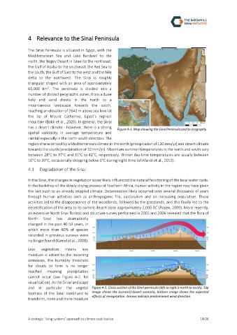
Figure 4-1. Map showing the Sinai Peninsula and its orography
spatial variability in average temperature and
rainfall especially in the north-south direction. The
region characterised by a Mediterranean climate in the north (precipitation of 120 mm/yr) and desert climate
towards the south (precipitation of 32 mm/yr). Maximum summer temperatures in the north and south vary
between 28°C to 37°C and 31°C to 42°C, respectively. Winter day-time temperatures are usually between
10°C to 20°C, occasionally dropping below 0°C during night-time (el Afandi et al., 2013).
4.1 Degradation of the Sinai
In the Sinai, the changes in vegetation cover likely influenced the natural functioning of the local water cycle.
In the backdrop of the slowly drying process of Northern Africa, human activity in the region may have given
the last push to an already crippled climate. Deterioration likely occurred over several thousands of years
through human activities such as anthropogenic fire, pastoralism and an increasing population. These
activities led to the disappearance of the woodlands, followed by the grasslands, and this finally led to the
desertification of the area to its current desert state approximately 2,000 BC (Rosen, 2009). More recently,
an extensive North Sinai floristic and structure survey performed in 2005 and 2006 revealed that the flora of
North Sinai has dramatically
changed in the past 40-50 years, in
which more than 60% of species
recorded in previous surveys were
no longer found (Kamel et al., 2008).
Less vegetation means less
moisture is added to the incoming
airmasses, the humidity threshold
for clouds to form is no longer
reached meaning precipitation
cannot occur (see Figure 4-2. for
visualisation). As the Sinai landscape
and in particular the vegetal Figure 4-2. Cross-section of the Sinai peninsula (left to right is north to south). Top
biomass of the Sinai continued to image shows the (current) desert scenario, bottom image shows the expected
effects of revegetation. Arrows indicate predominant wind direction.
transform, more and more moisture
A strategic ‘living systems’ approach to climate stabilization 14/26